Ever felt your heart skip a beat navigating the concrete jungle of New York City? You’re not alone. With millions of people, countless vehicles, and a dizzying array of streets, NYC’s roads can feel like a high-stakes obstacle course. But what if you knew exactly where the biggest dangers lurked? Understanding the city’s accident hotspots isn’t just about curiosity; it’s about protecting yourself, your loved ones, and everyone else sharing these vibrant streets. We’re going to dive deep into the data, pinpointing the areas where collisions, injuries, and even fatalities are most prevalent, so you can navigate smarter.
Decoding NYC’s Accident Data: The Truth on Our Streets
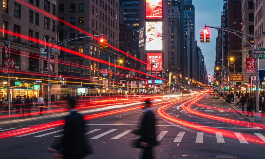
New York City isn’t just big; it’s complex, and its traffic patterns reflect that. The sheer volume of activity means accidents are, unfortunately, a daily reality. But thanks to incredible efforts by agencies like the NYC Department of Transportation (DOT) and the NYPD, we’ve got a clearer picture of where and why these incidents happen. Their Vision Zero initiative, launched in 2014, has been a game-changer, aiming to eliminate traffic fatalities and serious injuries. They tirelessly collect and analyze collision data, providing invaluable insights into what’s really going on out there. This isn’t just abstract statistics; it’s detailed information that shows us where the city’s most dangerous roads are, helping us understand the risks so we can all be a little safer. Aren’t you curious where your daily commute might fall on the risk spectrum?
Borough-by-Borough: Unmasking High-Risk Zones
While every borough sees its share of traffic incidents, some areas consistently stand out as higher risk. According to recent NYC DOT collision statistics, certain boroughs disproportionately contribute to the city’s overall accident rates. For example, Brooklyn, with its dense population, bustling commercial districts, and numerous major arteries like Atlantic Avenue and Flatbush Avenue, often reports the highest number of collisions involving injuries. It’s a vibrant borough, no doubt, but its intricate street grid and heavy traffic volume present unique challenges. Queens isn’t far behind, largely due to its extensive network of wide, multi-lane roadways and major expressways that encourage higher speeds, such as Queens Boulevard (often dubbed the “Boulevard of Death” in the past, though safety improvements have been made) and the Long Island Expressway service roads. Even Manhattan, despite its slower average speeds, sees a high number of pedestrian and cyclist injuries, especially in midtown and downtown areas where foot traffic is immense and interactions with vehicles are constant. Knowing this, you can’t help but wonder if your usual route takes you through one of these hot zones, can you?
Pinpointing Perilous Intersections: Where Danger Converges
It’s not just about the borough; often, it’s about specific intersections or stretches of road where multiple factors conspire to create hazardous conditions. These are the spots where drivers might make risky turns, pedestrians might misjudge traffic, or cyclists might be caught unaware. Let’s look at a few notorious examples.
One prime example is the intersection of Queens Boulevard and Roosevelt Avenue in Queens. This area is incredibly busy, with multiple lanes, complex turns, and heavy pedestrian traffic due to the nearby subway station and commercial activity. It’s a recipe for confusion, and sadly, for collisions. Another high-risk corridor is Atlantic Avenue in Brooklyn, particularly around areas like Fourth Avenue. This is a major thoroughfare that cuts through residential and commercial areas, often seeing drivers push speeds and pedestrians trying to cross multiple lanes. Similarly, in Manhattan, intersections along 1st and 2nd Avenues on the East Side, especially in the 50s and 60s, have historically been problematic due to high traffic volumes, bus lanes, and often aggressive turning movements by vehicles. These aren’t just random spots; they’re places where the city’s dynamism often clashes with the need for caution.
Vulnerable Road Users: Pedestrians and Cyclists in the Crosshairs
It’s crucial to remember that “car accidents” aren’t just about vehicle-on-vehicle collisions. New York City, by its very nature, is a walking and cycling city, and these vulnerable road users face disproportionate risks. Pedestrians are often involved in crashes at intersections, frequently due to drivers failing to yield during turns, especially left turns, or distracted driving. Cyclists, too, contend with similar dangers, in addition to dooring incidents and vehicles encroaching on bike lanes. The city has made strides with protected bike lanes and pedestrian safety campaigns, but the data still shows that a significant percentage of serious injuries and fatalities involve people not in cars. It’s a stark reminder that even if you’re not behind the wheel, awareness of these danger zones is incredibly important for your personal safety.
Untangling the Web: Common Factors Fueling Accidents
Why do these areas, and NYC in general, see so many accidents? It’s rarely a single issue; usually, it’s a confluence of factors. First off, distracted driving is a monumental problem. Whether it’s checking a phone, fiddling with the radio, or even just getting lost in thought, any moment your eyes aren’t on the road can have dire consequences in a city this busy. Then there’s speeding. Even going just a few miles over the limit can drastically reduce your reaction time, especially on crowded urban streets where a child could dart out or a taxi could suddenly stop. Failure to yield is another huge culprit, particularly at intersections and crosswalks. Drivers might rush a yellow light, or not see a pedestrian, leading to devastating outcomes. And let’s not forget improper turns or sudden lane changes, which can quickly trigger chain reactions. Sometimes, it’s also about infrastructure challenges—poorly marked lanes, confusing signage, or even construction zones that create unexpected hazards. It’s a lot to contend with, isn’t it?
Your Safety Playbook: Navigating NYC’s Roads with Confidence
So, what can you do with this knowledge? The goal isn’t to instill fear, but to empower you with information so you can navigate NYC more safely, whether you’re driving, walking, or cycling.
- For Drivers:
- Stay Laser-Focused: Put your phone away. Seriously. No text, call, or navigation adjustment is worth a life. According to the National Highway Traffic Safety Administration (NHTSA), distracted driving claimed 3,522 lives in 2021 alone. That’s a sobering thought.
- Obey Speed Limits: NYC has a default 25 mph speed limit unless otherwise posted. It’s there for a reason. Adhering to it gives you more time to react.
- Be a Defensive Driver: Assume other drivers, pedestrians, or cyclists might make a mistake. Look twice, then look again, especially at intersections and when turning.
- Plan Your Route: If possible, try to familiarize yourself with high-risk intersections and approach them with extra caution, or consider alternative routes during peak times.
- For Pedestrians:
- Use Crosswalks and Signals: Don’t jaywalk, even if it seems quicker. It’s incredibly dangerous. Wait for the walk signal.
- Make Eye Contact: Before stepping into a crosswalk, try to make eye contact with drivers. It’s a simple act that can confirm they see you.
- Avoid Distractions: Put your phone down. Don’t walk with headphones blaring. You need to hear and see your surroundings.
- Be Visible: Especially at night, wear bright clothing or use reflective gear.
- For Cyclists:
- Wear a Helmet: It’s the law if you’re under 14, but smart for everyone.
- Use Lights and Reflectors: Essential for visibility, especially at dawn, dusk, or night.
- Follow Traffic Laws: Obey traffic signals and stop signs. Don’t weave through traffic. Be predictable.
- Stay Alert: Watch for opening car doors (“dooring”), potholes, and aggressive drivers.
Closing Thoughts: Your Role in NYC Safety
Navigating New York City’s roads can feel like a challenge, but armed with knowledge about high-risk areas and best safety practices, you’re better equipped to protect yourself and others. We’re all part of this urban ecosystem, and our collective safety depends on individual vigilance. So, take this information, apply it to your daily travels, and let’s all work towards making NYC’s streets safer for everyone. What small change will you make today to improve your safety on the road?
Free Case Consultation
Injured in an accident? Contact Rosenberg, Minc, Falkoff & Wolff for a free and confidential case review with an experienced NYC personal injury attorney.